Nearmap, a location content provider specializing in high-resolution aerial maps, provides companies aerial imagery data that helps them find locations of interest; identify details around a property; and accurately measure details at a property
 |
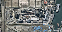
| A Nearmap Oblique capture of Ash Grove Cement’s Seattle operation. |
The company has long provided vertical imagery (orthorectified imagery) covering about 70 percent of the U.S. population. It recently extended its location content to include new aerial geospatial data services – Nearmap Panorama and Nearmap Oblique imagery – available through a new MapBrowser interface.
Nearmap Panorama is unique since it enables users to view perspective maps in all cardinal directions for small or large areas in uninterrupted fashion. Users do not need to jump from one image to another and, in the process, lose context. They can easily navigate, pan and zoom across any size geography, quickly analyze perspective maps and make faster decisions that impact government and commercial operations – all within an instantly accessible, 100 percent cloud-based environment.
Nearmap Oblique enables users to interactively inspect and measure the height of features, such as buildings and terrain, from all cardinal directions. Images are accessed through the new MapBrowser.
Users working within the MapBrowser interface can switch from Nearmap Vertical to Panorama or Oblique location content. “We’ve added new features that our customers are going to be very excited about,” said Natasha Ridley, product manager for MapBrowser. “For example, now users can export our imagery with measurements added. The saved image provides the whole picture, which is very useful in proposal development and communicating specific aspects of the aerial maps essential in planning and operations.”
“These enhancements represent a major step forward in both our location content and delivery capabilities. There’s also more on the way,” said Robert Carroll, vice president of 3D commercial and government for Nearmap. “This imagery is produced by our patented HyperCamera2 technology, enabling us to continue to proactively survey the U.S. urban areas including 50 percent of the population with obliques while also producing high-resolution 3D content. Our plan is to extend our leadership position by introducing Nearmap 3D, combining ‘off-the-shelf’ digital surface models (DSM), textured 3D mesh and 3D point clouds in the near future.”
Nearmap, go.nearmap.com